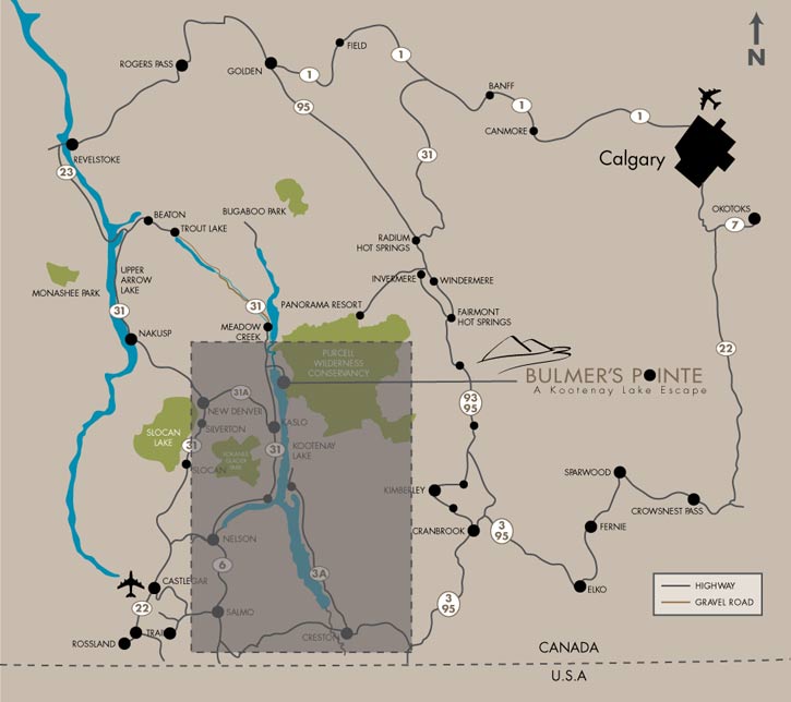
Smooth Route - Through Kaslo (Paved Road)
From Calgary (approx. 7.5 to 8.5 hours/640 kilometres)
|
|
- West on TransCanada Highway to Revelstoke
- South on Highway 23 to Shelter Bay/Galena Bay Ferry
- South from Galena Bay on Highway 23 to Nakusp
- Southeast on Highway 6 to New Denver
- East on Highway 31A to Kaslo
- North on Highway 31 to Meadow Creek
- Turn Right at Argenta/Johnson's Landing sign
- Turn Right Again at Argenta/Johnson's Landing directional arrows
- Turn Right into Bulmer's Pointe
|
409 km
48.9 km
46.6 km
46.6 km
46.2 km
34.2 km
1.2 km
10 km |
Fast Route - Trout Lake Road (Gravel Road)
From Calgary (approx. 6.5 to 8.0 hours/560 kilometres)
|
|
- West on TransCanada Highway to Revelstoke
- South on Highway 23 to Shelter Bay/Galena Bay Ferry
- South from Galena Bay on Highway 23 to HWY-31
- Southeast on HWY-31 to Meadow Creek
- Turn Left at Argenta/Johnson's Landing sign
- Turn Right Again at Argenta/Johnson's Landing directional arrows
- Turn Right into Bulmer's Pointe
|
409 km
48.9 km
1.9 km
103.8 km
1.2 km
10 km |
South Route - (Paved Roads)
From Calgary (approx. 7.5 to 8.75 hours/665 kilometers)
|
|
- South on Deerfoot TR/HWY-2 to Nanton
- West on HWY-533 to HWY-22
- South on HWY-22 to Crowsnest Pass
- West on HWY-3 to Creston
- North on HWY-3A to Kootenay Bay-Balfour Ferry
- East Northeast on HWY-3A to Kaslo
- North on Highway 31 to Meadow Creek
- Turn Right at Argenta/Johnson's Landing sign
- Turn Right Again at Argenta Johnson's Landing directional arrows
- Turn Right into Bulmer's Pointe
|
89.4 km
37.3 km
57 km
256 km
78 km
34.2 km
34.2 km
1.2 km
10 km
|
Click on the map below to get detailed area information.